UP dodges heaviest snow
Pleasant forecast for New Year’s Day, but more precipitation to come
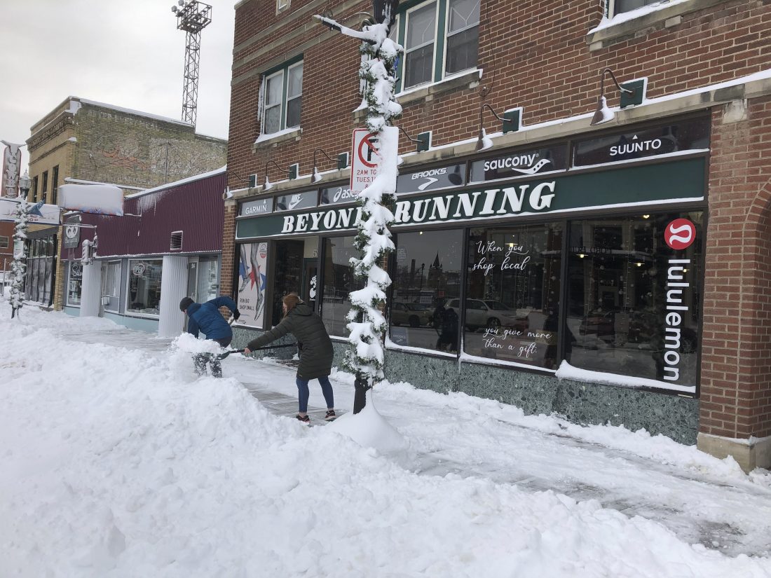
AP Photo Jake Olson, left, and Mackenzie Weinberger shovel snow outside of a store in downtown Fargo, N.D. on Monday, following a blizzard that dropped over a foot of snow in the area and closed streets, highways and many businesses.
A snowstorm that pummeled the northern Plains over the weekend brought wet, windswept snow to the Upper Peninsula on Monday as it moved east.
From 1 a.m. Monday through 7 a.m. today, snowfall totals in the Dickinson County area were expected to range from at least 6 inches to a foot or more. Wind gusts past 30 mph in the Great Lakes region will add to travel difficulties today, the National Weather Service said.
In the eastern U.P., an estimated 13,500 Cloverland Electric Cooperative members were without power Monday as a result of freezing rain, sleet and ice accumulation. Downed lines, trees on lines and broken poles were primary causes of the outages.
More snow could be in the works Thursday night into Friday as a storm system from the South spreads to the Midwest and Northeast. Locally, forecasters expect a chance of rain, then snow, although the exact track of the precipitation is uncertain.
The forecast for New Year’s Eve is partly cloudy with a low around 9, while New Year’s Day should be mostly sunny with a high near 26.
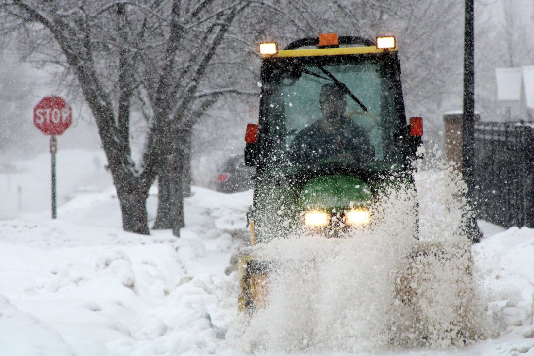
Theresa Proudfit/Daily News photo Matthew Jacobson clears the Cedar Avenue sidewalk on Monday outside the Oscar G. Johnson VA Medical Center in Iron Mountain. Jacobson is working in the VA’s Compensated Work Therapy program, which matches work-ready veterans in competitive jobs in consultation with business and industry.
Temperatures will soar into the high 30s Thursday afternoon before the next round of precipitation is expected to strike.
The storm that began over the weekend created blizzard conditions in parts of Minnesota, North Dakota and South Dakota. It shut down interstates, led to hundreds of vehicle crashes and brought a metropolitan area of more than 200,000 people to a standstill.
Residents in the Fargo and Moorhead, Minnesota area, who are used to snowstorms, were told to stay home after a foot of heavy, wet snow that fell on top of a sheet of ice made travel difficult and stoked early fears about spring flooding.
“This is one the worst storms we’ve had, just because we had ice on the bottom of it and we received several more inches than we expected,” Fargo Mayor Tim Mahoney said.
While the blizzard warnings were allowed to expire in the Dakotas and some portions of the interstate highways were allowed to open, the storm continued to linger in the region. The National Weather Service issued a winter storm warning Monday in northeastern Minnesota, northern Wisconsin and the Upper Peninsula.
Forecasters expected 10 to 14 inches of snow along Lake Superior’s south shore. Wind gusts topping 60 mph whipped up waves that crashed over shoreline barriers in Duluth and Grand Marais, Minnesota, causing localized flooding Sunday.
Greg Gust, National Weather Service meteorologist in Grand Forks, North Dakota, said the heaviest band of snow fell from Watertown, South Dakota through the Red River Valley corridor in eastern North Dakota, where amounts of 18 inches were common. Gust said the highest total so far was 21 inches in Ypsilanti — North Dakota, not Michigan.
Roof collapses were reported in Fargo and Virginia, Minnesota. Gust said the heavy, wet “Igloo snow” was making both driving and shoveling dangerous.
North Dakota Highway Patrol Captain Bryan Niewand said law enforcement responded to more than 50 rescue calls, most from people who drove on secondary roads because the interstates were shut down. Cass County Sheriff Jesse Jahner said some stranded travelers spent the night at a church in Page, northwest of Fargo.
Snow wasn’t the only issue during the weekend blast. Freezing rain on Saturday caused nearly 500 crashes on Minnesota roads and caused Metro Transit bus service to shut down in the Twin Cities, the first interruption of service in eight years.
Jonathan Wolfe, a National Weather Service meteorologist in Duluth, told the Star Tribune that Sunday’s precipitation and winds were just the first round of what he called an unusually strong winter storm. This season is already one of the top five snowiest to date for the area.
It also continued a trend of wet fall and early winter weather in the Red River Valley, where residents have dealt with chronic spring flooding for years. A diversion structure in Winnipeg, Manitoba, which prevents the north-flowing river from flooding the city, opened its floodgates in the fall for the first time, Gust said.
“The spring thaw and rain are always key factors (to a flood),” Gust said. “But we’re getting there. It’s setting up for a significant event.”
In Colorado, the weekend storm forced officials on Saturday to close Interstate 70 from east of Denver to Burlington near the Kansas state line. The roughly 160-mile stretch was reopened early Sunday.
The final snowstorm of 2019 in New England was packing a one-two punch that left skiers and snowboarders reveling, and others shoveling and chipping ice on Monday. Several thousand were left in the dark because of storm-related power outages.
The first wave of precipitation dumped up to a half-foot of snow on parts of southern Maine.
-

- AP Photo Jake Olson, left, and Mackenzie Weinberger shovel snow outside of a store in downtown Fargo, N.D. on Monday, following a blizzard that dropped over a foot of snow in the area and closed streets, highways and many businesses.
-

- Theresa Proudfit/Daily News photo Matthew Jacobson clears the Cedar Avenue sidewalk on Monday outside the Oscar G. Johnson VA Medical Center in Iron Mountain. Jacobson is working in the VA’s Compensated Work Therapy program, which matches work-ready veterans in competitive jobs in consultation with business and industry.
Local News
Dickinson clerk issues activity report for April
IRON MOUNTAIN — Dickinson County Clerk-Register of Deeds Carol K. Bronzyk has issued her activity report for ...

A case against grape jelly ‘For the Birds’

Half of deer ticks tested by Wisconsin researchers had Lyme-causing bacteria

Property tax elimination proposal fails to make Michigan ballot — again

A DC trip to honor those who served
IM accepts Five Star’s bid for water service line project
IRON MOUNTAIN — A Wisconsin contractor has been selected to perform a water service line project starting this ...