Fashionably late: Old Man Winter settles in for a longer visit
-

- A number of vehicles climb a snow-covered hill Thursday afternoon near the corner of Carpenter Avenue and W. Fleshiem Street in Iron Mountain. Snow fell throughout the evening and the coldest weather of the season is predicted in the wake of the storm. (Brian Christensen/Daily News photo)
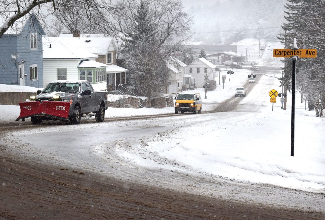
A number of vehicles climb a snow-covered hill Thursday afternoon near the corner of Carpenter Avenue and W. Fleshiem Street in Iron Mountain. Snow fell throughout the evening and the coldest weather of the season is predicted in the wake of the storm. (Brian Christensen/Daily News photo)
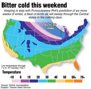
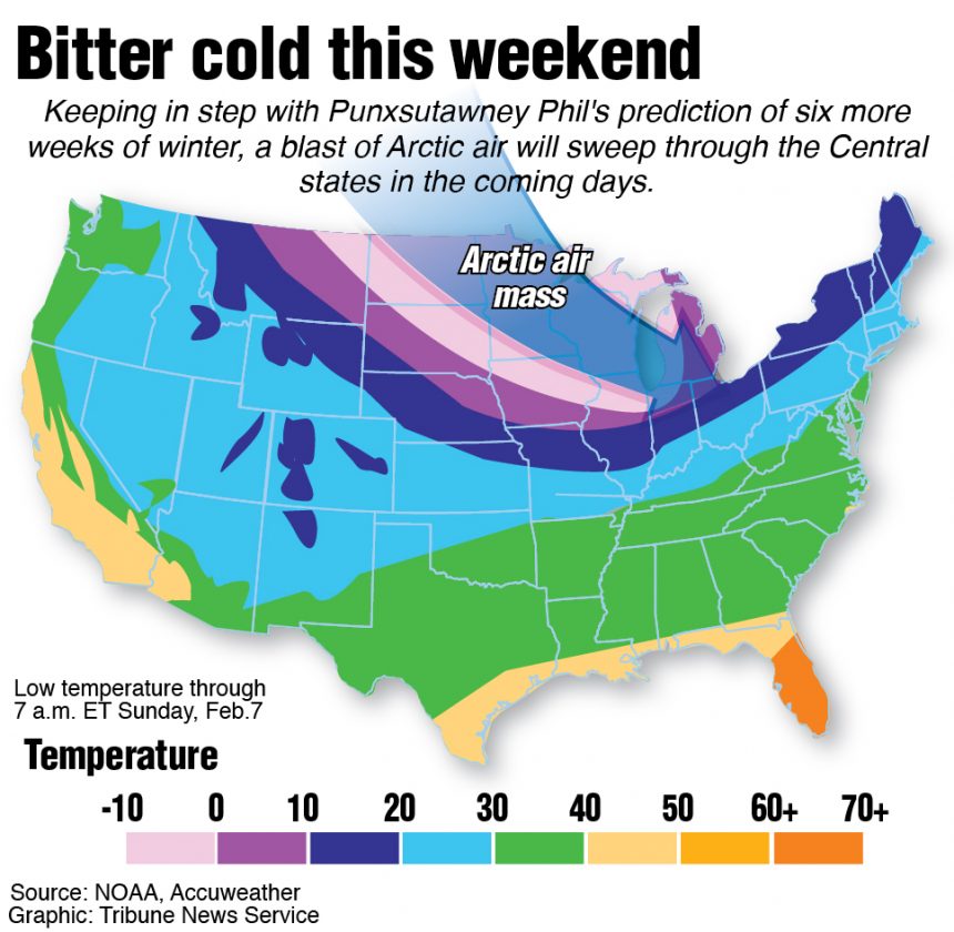
IRON MOUNTAIN — The winter’s first extended blast of Arctic air is expected to last through Wednesday as overnight lows dip to minus 12 this weekend, forecasters say.
Today’s high near 10 may be the warmest for the next several days as residents deal with the aftermath of Thursday’s snowfall.
After winter’s mild start, snow storms and frigid invasions could persist well into March, forecasters say.
For the Midwest, “spring weather may be slow to arrive due to a few spells of wintry weather still in the pipeline,” AccuWeather meteorologist Paul Pastelok said.
La Nina, a cooling of sea-surface temperatures in the central Pacific Ocean, is projected to continue through spring before weakening heading into early summer. Effects may include an active severe weather season, including storms across the northern U.S.
Meanwhile, a lack of Great Lakes ice coverage has implications for the end of the spring, Pastelok said.
“It could play out like a bit of a roller-coaster ride, and conditions can change dramatically from chilly in March and April to unusually warm in May,” he said. It may be “pretty wet” in March and April, he added.
For Iron Mountain-Kingsford, the National Weather Service predicts a 45% chance of above-average precipitation from now through the end of April, and just a 22% chance of below average. There’s a 36% chance of above-normal temperatures and a 29% chance of below normal.
This week’s snowfall comes during an unusually dry winter.
Snowfall in January measured just 4.3 inches, which was nearly 9 inches below average. Through the end of January, the Iron Mountain-Kingsford Wastewater Treatment Plant observation site had reported 17 inches of snowfall for the season, including 6 inches in October that quickly melted.
The maximum snow depth in January was 7 inches and water-equivalent precipitation totaled just 0.51 inches — less than half the normal amount.
Temperatures in January averaged 21 degrees, nearly 6 degrees above the trend for this century. November and December temperatures were also significantly above the norm.
The highest reading last month was 43 degrees Jan. 14 — a new record for that date — and the lowest was minus 1 on Jan. 28. To date, temperatures have dipped below zero just three days this winter, including readings of minus 6 on Dec. 29 and 30.
After a wet 2020, the U.S. Drought Monitor shows no areas of concern in the Upper Peninsula except in the far west. However, all of northwestern Wisconsin was listed as unusually dry before Thursday’s storm.
Elsewhere in the U.S., there is exceptional drought across most of Utah and portions of several bordering states.
Jim Anderson can be reached at 906-774-3500, ext. 226, or janderson@ironmountaindailynews.com.
Local News

Project tells the story of region’s indigenous people

U-M: Consumer confidence survey drops to 2022 lows

DNR seeks tips about dead eagles in Delta County

Researchers say Isle Royale’s wolves thriving as packs prey on moose
Courthouse to close early on Wednesday
IRON MOUNTAIN — The Dickinson County Courthouse in downtown Iron Mountain will close at noon Wednesday for ...