Warm fall predicted for UP, US
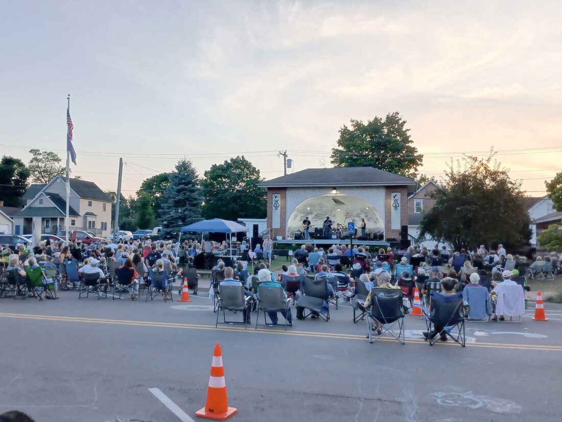
As cooler evening sets in, a large crowd enjoyed Norton, Chartier & Company at the ninth Music in the Park concert Thursday in Norway. (Mary Spera photo)
IRON MOUNTAIN — A warm autumn is expected across most of the U.S. this year as AccuWeather predicts temperatures in the Upper Peninsula may range 2 to 3 degrees above normal from September through November.
In its three-month outlook, the National Weather Services sees a 45% chance of above-average temperatures through October in the U.P. and just a 20% chance of below normal.
“One of the main headlines for the late summer and early fall is the potential for widespread warmth as above-normal temperatures are favored for virtually the entire nation,” NWS forecaster Scott Handel said.
The Pacific Northwest is the only region where forecasters see an early arrival of fall-like weather. “Outdoor projects and activities which you would typically see winding down during the fall season will continue well into the season for many areas,” AccuWeather meteorologist Paul Pastelok said.
In the near term, a burst of hot August weather is expected to continue well into next week, with highs reaching into the mid-80s through Thursday. There is a chance of rain or thunderstorms through early Monday.
With rising humidity, parts of the central and western U.P. could approach 100 degree heat indices today, the weather service said.
Temperatures in July at Iron Mountain-Kingsford averaged 70.5 degrees, which was 2 degrees above normal. The highest reading was 92 degrees on July 26 and the lowest was 47 degrees July 31.
Although just one day reached above 90, 19 of the month’s 31 days showed a daytime high of 80 degrees or better at the Iron Mountain-Kingsford Wastewater Treatment Plant observation site. It was the eighth-warmest July this century.
The warmest July on record was an average of 76 degrees in 1921 and the warmest this century was 73 degrees in 2012.
Iron Mountain-Kingsford rainfall measured 4 inches in July, which was more than a half-inch above normal. The U.S. Drought Monitor shows no areas of concern in the U.P. and northern Wisconsin, apart from abnormally dry conditions in parts of Wisconsin’s Vilas and Oneida counties.
The three-month precipitation outlook is neutral locally but slightly favors below-normal rainfall for the western third of the U.P. The winter outlook for the region is neutral for both temperatures and precipitation.
“As there is roughly a 90% probability that El Nino conditions will not be present during the winter, the forecast patterns resemble those more typical of La Nina,” Handel said. El Nino, which is marked by warmer-than-normal waters in the central and eastern Pacific Ocean, is linked to milder winters in the Great Lakes region.
For skywatchers, the Perseid meteor shower, named for its proximity to the constellation Perseus, will peak in the night between Tuesday and Wednesday. The shower usually features about 50 to 75 meteors per hour, but with the moon in its waning gibbous phase, observers may only see about 10 to 20 meteors hourly, according to the American Meteor Society.
———
Jim Anderson can be reached at 906-774-2772, ext. 85226, or janderson@ironmountaindailynews.com.
Local News

A whooping crane dies of avian flu at Wisconsin refuge
‘Pink Out’ volleyball matches today, Oct. 21 in Iron County
CRYSTAL FALLS — The Iron Area Health Foundation will again this year support the Iron County volleyball "Pink ...
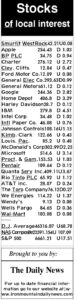
9-30 stocks
Diversity of the tropics featured in show Thursday
MARQUETTE — The beauty and the diversity of life in Costa Rica will be on display through photos from 7 to 8:30 ...

Students of the month