Major snowstorm expected to slam region this weekend

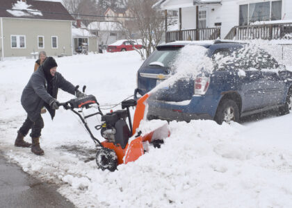
Dennis Baldinelli of Kingsford clears snow at a home on Iron Mountain's east side Friday afternoon. A storm expected to arrive late tonight could bring record-breaking snowfall to the region, according to the National Weather Service. (Marguerite Lanthier/Daily News photo)
IRON MOUNTAIN — Potentially record-breaking snowfall is predicted for the Upper Peninsula and northern Wisconsin as a storm system arrives late tonight, with widespread snow totals exceeding a foot and some locations along Lake Michigan seeing up to 3 feet of snow, the National Weather Service said.
A winter storm watch will be in effect from late tonight through Monday evening, forecasters said.
It’s possible some local roads may not be plowed until late Tuesday, the Dickinson County Road Commission said in an advisory issued in coordination with the sheriff’s office. Top priority will be to keep Michigan Department of Transportation highways plowed and open.
“High traffic volume primary roads will be plowed as much as reasonably possible to keep those roads open,” the commission said. “There will likely be deep snow and extreme drifting, possible power outages and trees down in the roadway, making travel with most passenger vehicles extremely difficult or impossible,” the DCRC advisory stated.
Crews will be out working extended shifts for as long as it takes to get all the roads plowed, DCRC added. Residents are advised they may potentially be “snowed in” through Tuesday evening on local roads and streets.
Some alleys and gravel roads may not be plowed until Wednesday or Thursday, as deemed practical.
The forecast calls for a high of 28 on Sunday, 18 on Monday and 22 on Tuesday. Winds on Sunday could gust as high as 35 mph and Monday is expected to be blustery.
Warmer weather could take hold later in the week, with a predicted high of 44 on Thursday.
The city of Iron Mountain said garbage collection will be delayed by a day next week, with Monday’s pickups on Tuesday; Tuesday’s pickups on Wednesday; and Wednesday’s on Thursday.
Upper Peninsula Power Co. said repair crews are standing by.
“Power outages may occur as strong winds and heavy snow moves through the region,” said Dan Freeborn, UPPCO’s manager of Communications and External Affairs. “UPPCO crews are prepared to respond to outages should they occur.”
The public is advised to never approach or touch a downed power line or anything in contact with one. “If you see a downed line, stay at least 35 feet away and call 9-1-1 immediately,” Freeborn said.
In Wisconsin, the Marinette County Highway Department urges the public to stay off the roads during the storm. The Marinette County Roadway Weather Information Systems predict 20 to 29 inches of snow along with high winds that will cause blowing and drifting snow.
“Highway Department crews will be working throughout the storm. However, the snowfall rates and wind conditions may slow their ability to keep the roads clear,” said Jessica Demler, Marinette County Emergency Management coordinator. “Keeping roads free of unnecessary traffic will allow for more effective snow removal operations and help emergency responders operate safely and efficiently,” she said.
According to AccuWeather, blizzard conditions are possible in portions of Wisconsin, Michigan, Iowa, northern Illinois and southeastern Minnesota. From 1 to 3 feet of snow is forecast to pile up from near Minneapolis and Green Bay, Wis., extending to the Upper Peninsula.
Rain and a wintry mix will change to some snow in southern Michigan and around Chicago, AccuWeather said.
About 8 to 12 inches of snow fell in the Iron Mountain-Kingsford area and neighboring communities during a storm that began early Friday morning and continued into the afternoon.
Local News
Major snowstorm expected to slam region this weekend
Michigan to again offer children free summer food programs
LANSING, Mich. — Michigan children will continue to benefit from free, healthy and nutritious meals during the ...

Marquette road to be closed for salamander migration
Freeze Your Bass Off returns on Saturday to Crystal Falls
Meeting Tuesday of the Menominee County Dems
MENOMINEE — Menominee County Democratic Party will meet from 5:30 to 6:50 p.m. Tuesday in the ground-floor ...
Daily News office closing early today
IRON MOUNTAIN — Due to staff being needed to set up the Spring Craft Show, The Daily News office will close at 2 ...