
At least three tornadoes confirmed in UP last week
Trending
ESCANABA -- At least three tornadoes touched down in the Upper Peninsula during a weather event last Monday, the National Weather Service reported Friday.
One was at Delta County's O.B. Fuller Park; the other two were in Marquette and Menominee counties.
The conditions Monday evening formed multiple supercells, according to a NWS Marquette office statement. A supercell is the least common type of thunderstorm and has a "high propensity to produce severe weather, including damaging winds, very large hail, and sometimes weak to violent tornadoes," the NWS said in the statement. "What makes a supercell unique from all other thunderstorm types is that it contains a deep and persistent rotating updraft called a mesocyclone."
As people around the region took shelter last Monday, a waterspout formed at 6:31 p.m. Eastern time off Shot Point, which is on Lake Superior between Marquette and Au Train. "Video and radar evidence suggest a waterspout moved on shore, (but) no surveyable damage was found by storm survey team," the NWS report states.
At 6:47 p.m. Central time, a tornado formed in Gourley Township in Menominee County. The NWS estimates its peak wind was 104 mph, its width was 35 yards, and the length traveled was 0.14 miles. Damage was caused to "mostly large white pines of approximately one to three feet in diameter," the report stated. As remote areas were not accessible, the storm survey may be updated later.
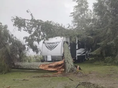
At 7:58 p.m. Eastern time, about 5 miles from the previous tornado, another one touched down in the woods of Fuller Park in Ford River Township in Delta County. The NWS survey indicated that a tornado with a peak wind speed of 90 mph damaged a stand of softwood trees before shifting offshore. The path had a maximum width of about 25 yards and a length of 0.3 miles.
Additional damage in the areas of the latter two tornadoes was consistent with straight-line winds. Both were classified as EF1 on the scale used to score tornadoes, which is the second-weakest based on wind speed. The one that touched Lake Superior was uncategorized, as there was no damage to survey.
In all three events, no human injuries were reported.
"The NWS Marquette Weather Forecast Office would like to thank the public, the Delta County and Menominee County Sheriff departments, and the employees of O.B. Fuller County Park, whose information helped complete this storm survey," the report concluded.