Another icy storm predicted
IRON MOUNTAIN — Mixed precipitation could cause power outages tonight into Wednesday and ice will make travel hazardous across much of the Upper Peninsula, the National Weather Service said.
“As a warm front pushes into the area tonight, expect sleet and freezing rain to move in from the Wisconsin border region into the rest of Upper Michigan,” the NWS Marquette office said.
Ice accumulations could range up to a quarter-inch, with some of the highest amounts near the Wisconsin border, forecasters said.
There is a small chance that sleet will change over snow at times if the precipitation rate is heavy enough, forecasters said. Wednesday’s forecast calls for freezing rain turning to rain after 10 a.m., with a high temperature near 36 degrees in the Iron Mountain area.
A storm system that hit the region just a week ago caused tens of thousands of power outages across the U.P. and northern Wisconsin as ice accumulated on power lines and tree branches.
Local News

Michigan lawmakers revive push to legalize physician-assisted suicide

Public voting begins for Michigan’s ‘I voted’ sticker design contest
Initial findings released from PFAS in firefighters state study
LANSING, Mich. — The Michigan Department of Health and Human Services has released findings from a project to ...

MDOC raises pay for new officers at five UP prisons
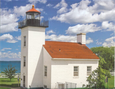
Sand Point Lighthouse: A shoreline sentinel of history