Ottawa National Forest seeks public input in planning project
IRONWOOD — The Ottawa National Forest is announcing the scoping phase of the Drumloid Vegetation Management Project. The public is invited to participate in the planning of this project, which is within the Iron River and Watersmeet Ranger Districts, which includes Iron and Gogebic counties.
The area includes about 47,900 acres of National Forest System lands midway between Watersmeet and Iron River. Federal Forest Highway 16 and U.S. 2 traverse the middle of the project area. The proposal includes vegetation treatments to maintain or improve forest health and diversity through timber harvest within aspen/birch, conifer, and northern hardwood forest types.
The proposal also includes activities to reduce hazardous fuels; refine the transportation system for administrative and public access; maintain or improve habitat conditions and riparian areas, including improvements to the South Branch Paint Wild and Scenic River corridor; refine old-growth classifications and expand existing gravel pits. Additionally, temporary openings that exceed 40 acres will be evaluated as part of this project.
The scoping documents for this project describe the purpose and need for action and a detailed summary of the proposed actions, as well as background information and the next steps. An Environmental Assessment is anticipated to analyze the effects of the proposed action. The responsible official, Anthony Holland, district ranger, would use the EA to determine if the project would result in any significant impacts.
To review the project proposal, a copy of the scoping letter and associated maps for the area can be requested at any Forest Service office or viewed the online on the Ottawa’s website: https://www.fs.usda.gov/projects/ottawa/landmanagement/projects.
For more project information, contact Christy Makuck, team leader, at 906-358-4032, or christine.makuck@usda.gov.
Local News

Occhietti scholarships awarded
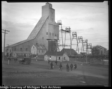
Michigan copper critical to Union victory in Civil War
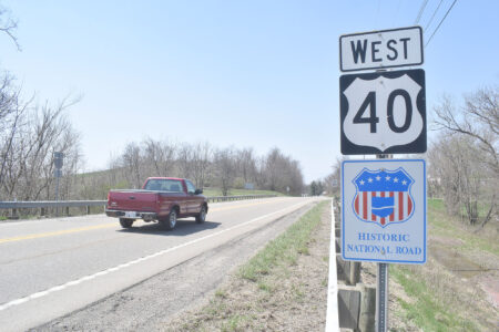
National Road connected a young nation
Forest Park names top 10 in Class of 2026
CRYSTAL FALLS — Forest Park Schools has announced its top 10 seniors in the Class of 2026. — Maykayli ...

Michigan cities, counties have spent 18% of opioid settlement funds